Revisiting a Journey to Freedom: 175 Years Later
By Dan Matterazi, Jim Blanchard, and Geeta Shanbhag
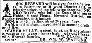
In the summer of 2023, we were asked by researcher and author Stephanie Gilbert to help find the location where Oliver Gilbert (her great-great Grandfather) escaped from slavery on Sunday Aug 20th, 1848 from Howard County. What we knew at that time was that Oliver Kelly (name changed to Oliver Gilbert after the escape) had been enslaved and worked as a waiter at Richland near Clarksville Maryland. He and 14 other slaves had planned to escape from a Methodist Episcopal Camp Meeting about 15 miles North of Clarksville with the help of a local miller. The camp meeting was held on the grounds of Hobbs Schoolhouse near Cooksville Maryland
Initial research focused on finding the background of the Hobbs family as well as the two different ME church groups (St James and Mckendree) in the Cooksville area at that time. The McKendree church property was provided by Henry C Hobbs Jr, and according to some books on the history of Cooksville Henry C Hobbs Jr had also provided property for a Schoolhouse. The McKendree congregation met in the Hobbs Schoolhouse until the first church log structure was built in 1844. It turns out that Henry’s son Charles the 1st also provided property for another schoolhouse in the Cooksville area around 1872. Both Henry and subsequently his son Charles owned “Hobbs’s Regulation” which consisted of about 380 acres in the early 1800’s and is still owned by a Hobbs direct descendant today, but is now about 195 acres.
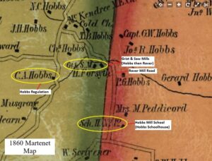
Looking at the 1860 Martenet Map of Howard County there is a Schoolhouse #12 (Only one that could have been a part of Hobbs Regulation property at that time) shown on “Rover Mill Road” which was known as Hobbs Mill Road prior (Hobbs owned a sawmill East of his home). So, we focused on that schoolhouse as the possible location of the Hobbs schoolhouse that was the point of the slaves’ escape.
Both the names “School House No. 12” and “Hobbs Mill School” had appeared in the written records of the Howard County Board of Education meetings. (Presumably “Hobbs’ Mill School” was just another name for the “Hobbs’ School House,” or vice versa.) The earliest Board of Education records consisted exclusively of financial records: school expenditures and receipts for all the schools for the years 1853 to 1864. There was nothing in these records that tied School House No. 12 to Hobbs’ Mill School.
Sometime between 1864 and 1868 the sequentially numbered schools had been reapportioned to the various election districts, and they were now referred to by just their number. Under this system, Hobbs’ Mill School had initially been designated as School No. 3 in District No. 3. But then in July of 1868 the schools were renumbered again, and Hobbs’ Mill School became known as School No. 4 in District No. 3. Hoping for additional clues, we looked in later maps of the six districts in Howard County from the 1878 Hopkins Atlas. Unfortunately, the school houses were not identified by number in any of those maps. So, the only correlation that School House No.12 was Hobbs Mill School was that it was located on what was Hobbs Mill Road and was at the Eastern boundary of Hobbs Regulation. Also, according to BOE minutes, a discussion about replacing Hobbs Mill School happened in 1868. This information along with the 1872 deed where Charles Hobbs provided ¼ acre plot for a schoolhouse indicates that School House No 12 on the 1860 map would no longer exist as a schoolhouse on the 1878 map.
Looking at a current map we noticed that besides Rover Mill Road there also was an “Old Rover Road”. Taking precise scaled measurements on the 1860 Martenet Map from Schoolhouse #12 to a mile marker on Frederick Road, and then overlaying the scaled measurement onto a current map, was able to place the approximate location of schoolhouse 12 at the inside corner of “Old Rover Road”. That allowed a starting point to do a historical property trace which produced a deed in 1882 for 5 acres by a James Hacket at that corner while also referring to the “schoolhouse field”. That was enough for Stephanie Gilbert to contact people living in that area and arrange a meeting with them on Sunday the 20th of August which was the 175th anniversary of Oliver’s escape. Stephanie wanted to trace Oliver’s flight to freedom on this very special anniversary.
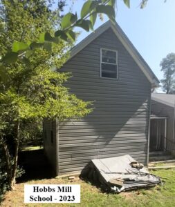
When meeting with the current residents on Old Rover Road they surprisingly pointed out that the schoolhouse was still there! It was covered over with new siding, a new roof, and an addition where a family member lived. The field of the schoolhouse was also still there……subsequently an earlier property deed was found that said “Schoolhouse No.12” confirming the location. Apparently, Charles Hobbs sold off a chunk of property to W. Scrivner who subsequently sold off smaller parcels which changed ownership over time. The start of the escape to freedom by Oliver Kelly (Gilbert) was found.
This was a HCHS team effort working with Stephanie Gilbert that produced the success in a constrained schedule. It included collaboration, exchanging theories, challenging conclusions, and working together to make it happen.
In summary Schoolhouse No.12 is located on what was called Hobbs Mill Road and is on the Eastern edge of the old Hobbs Regulation property. It is also the only schoolhouse in that district noted on the 1860 map near Hobbs Regulation.
Recent Comments